Posts

King Khalid International Airport (RUH) or Riyadh Airport

Image
King Khalid International Airport (RUH) or KKIA Airport IATA:                      RUH ICAO:                      OERK Airport Type:            Public Owner:                    The Saudi General Authority of Civil Aviation (GACA) Location:                 Riyadh, Saudi Arabia Hub:                       Saudia, Flynas Elevation AMSL:         2,049 ft / 625 m Coordinates:             24°57′28″N 046°41′56″E King Khalid Internal Airport commonly known as Riyadh Airport. Riyadh is the capital city of The Kingdom of Saudi Arabia. It is situated in the central portions of both Saudi Arabia and the larger Arabian Peninsula. King Khalid International Airport was opened in 1983 in Riyadh City. It is located about 35 km from the city center, containing five passengers terminals, 40 Passenger boarding bridges and more car parking designed for 11,600 vehicles. The airport consists of Royal Terminal, the Central Control Tower, two Parallel Runways, which are each 4,260 meters lon


King Abdulaziz International Airport, Terminal 1 (JED)

Image
  King Abdulaziz International Airport, Terminal 1 IATA: JED ICAO: OEJN Location: Al Madinah Al Munawwarah Road, Jeddah, KSA Hub for: Saudia, Flyadeal, Flynas Operator: General Authority of Civil Aviation (GACA) Coordinates    21°40′46″N 039°09′24″E The General Authority of Civil Aviation is seeking ways to create a hub airport connecting the west with the east. In August, 2019, the new Terminal 1 at King Abdul Aziz International Airport had a soft opening with a number of domestic flights transferred to operate from it. The airport started moving a number of international flights operated by Saudia to the new terminal, and on the 18th of November, Etihad became the first non-Saudi airline to move to the new facility. Size of the Terminal:           810 square km.  Check-In Counters:              220. Self-Service Desk:               80. VIP Lounge:                          Total 11254 square meter. Shopping Area:                   27987 square meters. Airport

Hong Kong International Airport (Kai Tak Airport), Hong Kong

Image
Hong Kong International Airport (Kai Tak Airport), Hong Kong. Just before the final approach of Kai Tak (HKG) was so close to those buildings that passengers could spot television sets in the apartments as the aircraft banked sharply to the right for landing  nearby apartments that seemed an arm's length away. Kai Tak is named after two businessmen, Sir Ho Kai and Mr. Au Tak, who were involved in a company formed to reclaim land in Kowloon Bay for a residential housing scheme. The Company, unfortunately, failed and the reclaimed land was left vacant. The suitability of using this land as an airfield was recognized and the first recorded flight from Kai Tak took place on Lunar New Year's Day in 1925. IATA: HKG ICAO: VHHH Opened: 25 January 1925 Closed: 6 July 1998 Operator: Civil Aviation Department Location: Kowloon, Hong Kong Elevation AMSL:   9 m / 30 ft Coordinates :  22°19′43″N 114°11′39″E Kai Tak Airport was the international airport of Hong Kong from 25 th

LUA, Lukla Airport, Nepal

Image
LUA, Lukla Airport, Nepal Lukla Airport or Tenzing – Hillary Airport, is the closest Airport to Everest and Everest Base Camp. Lukla Airport is located in the town of Lukla, in Khumbu Pasanglhamu, Solukhumbu District, Province No. 1 of Nepal. IATA:                      LUA ICAO:                      VNLK Owner:                   Government of Nepal Operator:               Civil Aviation Authority of Nepal Serves:                   Lukla, Nepal Hub:                       Air Dynasty Time Zone:             NST (UTC+05:45) Elevation AMSL:      9,337 ft / 2,846 m Coordinates            27°41′16″N 086°43′53″E The airport is popular because it is considered the starting point for treks towards Mount Everest Base Camp. There are daily flights between Lukla and Kathmandu during daylight hours in good weather. Although the flying distance is short, rain commonly occurs in Lukla while the sun is shining brightly in Kathmandu. High winds, cloud cover, and changing

NDC: New Distribution Capability

Image
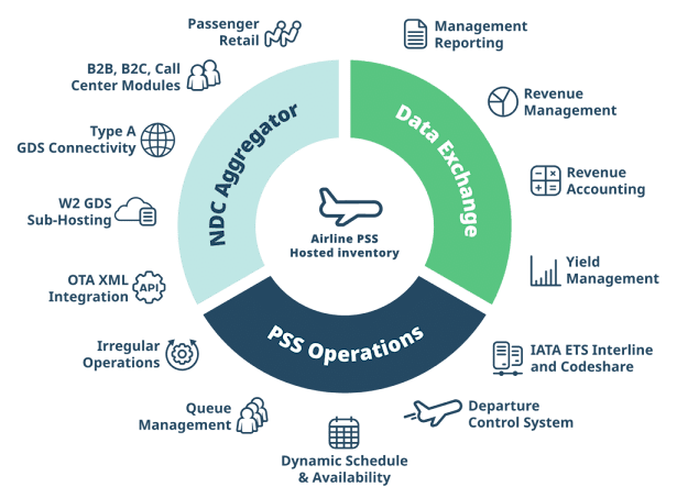
New Distribution Capability (NDC) New Distribution Capability (NDC) is a Data Exchange Format based on Offer and Order Management Processes for Airlines to Create and Distribute relevant offers to the customer regardless of the distribution channel. ​​​​ During the 1970s, Airlines created computerized ticket reservation systems, known as Central Reservation Systems (CRS), to help their agents search, book, and confirm flight bookings. Having proven to be an extremely efficient tool, the airline industry looked to reduce their booking workloads by allowing travel agents to make bookings directly on the CRS. However, each airline had its own unique CRS. To gain access to the flights of every airline, travel agents in the US demanded for and received a single CRS platform. This remained the status quo for over 20 years. Customers called the travel agents, who then booked their flights on the CRS. However, in the 1990, the major CRSs namely Sabre, Amadeus, and Worldspan & Galil